This post will cover the most interesting urban centres of New Zealand. I have divided it up by town with photos following each entry so keep on scrolling. The final post on New Zealand (in a few days) will deal with the natural wonders which abound, especially on the South Island.
Wellington
Wellington is the capital of New Zealand but does not have a
large population—only 200,000 in the city and 400,000 in greater Wellington. Although
it has a fine setting in a protected bay which in turn is protected from the
ocean by the Cook Straight which separates the North and South Island, it is
not a particularly attractive city for a visitor.
The downtown area, which is
filled with a motley collection of buildings none of which have much
architectural merit and are interspersed with parking lots, is on a narrow
strip of flat land which runs around the edge of the bay and from there the
city rises steeply up the surrounding hills. There has been a valiant effort to
revitalise the harbour and docks along the waterfront but somehow it doesn’t
seem to have much life to it. The worst aspect of the city is a motorway which
cuts through its heart, built in the early 1980s before people fully understood
how motorways destroy a city’s cohesion.
Although the business area is on the thin flat coastal plane
and on the lower slopesof the surrounding hills , the residential area is scattered in the trees and
shrubs of the upper hillside accessible in many cases by cable cars—apparently there
are over 400 private cable cars to reach individual residences on the steeper
slopes. The residential suburbs spread out to the north, east and the west. I
suspect that there are some lovely homes up there on the wooded slopes.
Since Wellington is the capital of New Zealand there is a
government section which includes the modern and aptly named “Beehive”, which
is the new parliament building. Far more attractive is the original “Government
House” which is actually made of wood although made to look like stone.
The best things about Wellington? The lovely Botanic Gardens
on the upper slopes of a hill, reached by a fine nineteenth century cable car
established in the nineteenth century. You can then walk down through the
gardens to the main part of the city. It contains a wonderful selection of trees and shrubs as well as
flowers, with well-marked pathways.
And the second noteworthy thing about
Wellington is the fabulous new Te Papa (meaning “our place”) Museum. It is
right on the waterfront in a dramatic modern building. And it is huge. You
would need days to see it all. Excellent free guided tours by enthusiastic and
knowledgeable volunteers run frequently.
There are informative exhibitions on
Maori culture; the geology of New Zealand and its earthquakes and volcanoes;
immigration to New Zealand; the native flora and fauna including the sad
process of extinction of native species like the large ostrich-like flightless
Moa and the denuding and erosion of the countryside by clear-cutting the native
trees and the planting of foreign grasses for grazing sheep and cattle; and the
vibrant film industry which has produced so many blockbusters in the last 15
years. All these exhibits make use of the latest audio-visual and interactive
techniques but without any dumbing down of what is being exhibited.
 |
| The old Wellington cable car climbing the hill to the Botanic Garden, the university and the lovely houses on the hillside |
 |
| The rather unattractive motley collection of architecture in the downtown area of Wellington |
 |
| Some of the fie houses which hide amongst the trees on the slopes of the steep hills surrounding central Wellington |
 |
| More such residential areas seen through the fine trees in the Botanic Gardens |
 |
| Tombstones in the old settlers cemetery, which was partly destroyed by the ugly motorway which cuts through the centre of the city |
 |
| The "Beehive", the modern parliament buildings of Wellington |
 |
| The infinitely more attractive old Government Building which believe it or not is made of wood |
 |
| The modernistic Te Papa museum which has wonderful exhibits (as explained in the blog post) |
 |
| Beautiful begonias in the Wellington Botanic Gardens |
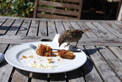 |
| a cheeky sparrow finishing off my carrot cake in the Botanic Garden cafe |
Auckland
I didn’t see much of Auckland’s centre since I was staying
with my cousin in the south eastern suburb of Half Moon Bay, but I am not sure
that I missed a great deal. With a few notable exceptions large city centres do
tend to be very much alike.
Auckland is the
largest city in New Zealand by far—1.5 million. But it is also one of the least
densely populated cities in the world: that population is spread out over 1090
square kilometres. This compares to the population of Greater London which is
over 8 million people in an area of 1500 square kilometres.
As a result
Auckland consists of miles of suburbs and associated shopping centres and light
industry reached by many motorways and major roads. It is really very like a US
city in that way. I cannot imagine that you could survive in Auckland without a
car.
Most people seem to live in attractive suburban or
semi-rural single family dwellings with nice gardens (although there may be
slummy areas that I did not see). The climate is subtropical and so trees,
shrubs, flowers and grass flourish. I
was aghast to learn however that planning controls are very lax and there is
very little restriction on people subdividing their lots (called “sections” in
New Zealand) and building another house and selling it off.
Auckland is located at a point where the North Island
narrows and the coast line breaks up into a series of channels and bays before
reassembling and continuing on a long arm north to the Bay of Islands.
As a
result Auckland, with its benign climate, protected harbours, and easy access
to the sea both to the west and to the east, was --and is-- a natural place for
settlement. You are never far from the sea wherever you are in Auckland and
because of the abundance of sheltered coves and beaches it is easy to pop down
to a beach and none of them seem to be overcrowded.
An interesting feature of Auckland is the extinct volcanoes
that dot the otherwise flat city-scape. These are not much more than hills and
are not more than about 150 metres high. Many have been levelled and buried under houses
built on the slopes, but nevertheless they are distinctive particularly if you
are on the top of one of them and can see several more of them in the
surrounding area. There are at least 50 of them.
Apparently Auckland is situated
on a “volcanic field”. This is different from the other better-known and more
dramatic types of volcanoes—cone volcanoes and caldera volcanoes (for more on
this see what I have to say in the next post about the volcanoes in Tongariro National
Park). A volcanic field consists of a wide area that contains many small
volcanoes that erupt once and then are extinct. Further volcanic activity in
the area will come from a new small volcano not a further eruption from one of
those that has already erupted.
So in contrast to other parts of New Zealand
the existing small volcanoes in Auckland pose no threat of future
eruption---but of course there is always the possibility (probably remote) of a
new small volcano popping up! There is a “proper” cone volcano on Rangitoto
Island off the east coast of Auckland
which erupted only 600 years ago and is still a wasteland of lava.
Auckland is a place that I must return to since I never got
across the bridge to the large part of the city on “North Shore” nor did I get
further north to the long peninsula which runs a further 500 kilometres north to
the Bay of Islands and apparently is full of nature sites and the few remaining
forests of the once plentiful indigenous kauri tree.
 |
| The Auckland skyline from one of the many bays and inlets that surround the city |
 |
| Not a good picture, but you can see the low mounds which are extinct volcanoes (see explanation in the blog post) |
 |
| An early settler's cottage, preserved in an Auckland park. The New Zealand style of domestic architecture has not changed excessively ---still mostly bungalows with porches |
 |
| One of the dozens of deserted beaches that are hidden along the coastline of Auckland's suburbs |
 |
| My only swim |
Christchurch
The other major city of New Zealand which tourists visit is
Christchurch on the South Island. This was my first and my last stop on my
trip. Christchurch struck me as a very liveable city. While it is quite spread
out there are many attractive residential areas quite close to the heart of the
city. The city’s crown jewel is the outstanding Hagley Park with the charming
river Avon running through it.
As is well known, Christchurch was hit by a series of
devastating earthquakes and after-shocks in 2010 and 2011. These
quakes destroyed much of the business heart of the city including toppling the
tower and walls of the neo-Gothic cathedral which was the focal point of the
city.
Even the houses and buildings which look unscathed are not so. The quakes
caused a phenomenon called “liquefaction” which involves a change in the
composition of the sandy soil so that the particles of soil compact, releasing
the water which was dissolved in the soil.
The ground sinks and develops
fissures. This causes major subsidence below the buildings and cracks appear in
the foundations and walls, while geysers of mud spray up through cracks in the
ground and covers the buildings and gardens.
As a result of these two years repeat
disasters and the uncertainty of whether it may happen again, I understand that
many people have moved away.
The central part of the city is now called the “Red Zone” which
is a no-go wasteland of abandoned buildings and rubble-strewn half-cleared
lots. A small section has been turned into a shopping and café area called
“Re-Start” made out of brightly painted shipping containers.
To be perfectly honest, I was quite disappointed to see how
little progress has been made in rebuilding anything or repairing and
re-opening the buildings which are not condemned. Granted, the city fathers
wanted to consult widely on how the city centre should be reconstructed, and
there was naturally concern about whether the two years of earthquakes and
after-shocks was really over, and I understand the insurers have put up one
heck of a fight against claims (Quelle surprise!!).
But still, I really did think more could and should have
been done, particularly in the lovely Botanic Gardens where even the cafes,
conservatories and greenhouses remain closed. I didn’t sense any energy or “can
do” spirit, particularly when one contrasts the public and private response to
the devastating earthquake in Napier in the 1930s (see later in this post.) It
almost looks as though Christchurch is marking time, maybe thinking that they
won’t have to rebuild after all because the city is done-for.
 |
| One of the buildings destroyed in the earthquakes but not yet demolished |
 |
| An abandoned shopping mall in the "Red Zone" |
 |
| The ruined cathedral |
 |
| The pretty Avon River that winds through Christchurch, with fencing behind which are more earthquake-damaged buildings |
 |
| "Re-Start", the temporary shopping area made of shipping containers |
Napier
Napier is the main city on the east coast of the North
Island. From either Wellington or Auckland and the main north-south transport
routes, it is a long and rather boring drive across dry brown hills and
mountains denuded of trees and then miles and miles of grazing country
interspersed with small towns.
These towns are not very attractive, usually consisting of one main street with a
straggle of false-fronted commercial buildings with vacant lots in between, and
a couple of cross streets with a few residential streets of small unimaginative
bungalows behind the main street. Quite
“frontier”.
But the long drive is worthwhile in my view. Napier is the centre
of the famous “Hawkes Bay” wine district, surrounded by orchards and market
gardens and with a fine large harbour for commercial shipping and fine wild
Pacific Ocean beaches with plenty to please those looking for seals and sea
birds.
But that is not why I went there. Napier is famous for its small
but perfect Art Deco commercial heart, which has successfully avoided the
developer’s wrecking ball and yet has remained a viable business centre for the
city. This is in large part due to the fiercely protective and very active Art
Deco Trust which has turned the city into a must-see for many tourists such as
me and runs excellent guided tours.
I always loved the
Art Deco buildings of Miami Beach, and Napier is if anything better since rather
than being established as a collection of modest seaside hotels and boarding
houses like Miami Beach, Napier was built as a proper commercial heart for a
small city which had been devastated by a massive earthquake in 1931.
The story of the earthquake and the rebuilding of the city
is fascinating in itself. Before the quake Napier, which had been founded as
the shipping port on the Pacific Ocean side of the North Island in the
mid-1800s, consisted of a small cliff about 100 metres high sticking out into
the sea flanked by two low-lying sand and shingle bars stretching on either
side. One of these sandbars enclosed a huge saltwater lagoon deep enough to
provide a good sheltered harbour. As the town boomed in the era where maritime
shipping was the only way to transport goods and people, it grew up the slopes
of the cliff and along the sand bars but by the early twentieth century it had
started to run out of solid ground to build on.
This dilemma was solved for them in an extraordinary way in
February 1931 when a 7.9 magnitude earthquake flattened most of the commercial
centre of the town and raised the land on which the city was built over two
metres (seven feet! Imagine!) . This
also raised the salt water lagoon which had been the original port, so that it
was almost completely drained, delivering nearly 300 square kilometres of new
land on which to build.
Spared were the
wooden buildings since they were more flexible than stone or brick to move with
the swaying of the earthquake. However the raging fires which burnt over the
next two weeks took care of many of they although many of the residential homes
on the sides of the cliff most of which were of wood were spared.
Also spared
was a fine line of Norfolk pine trees which had been planted along the sea
front promenade a few years earlier. They did were entirely unscathed, only
suddenly seven feet higher!
In a unique display of common sense and foresightedness the city
seized the opportunity to rebuild an harmonious commercial and civic town centre,
in the latest architectural and decorative fashions of the day which in the
early thirties were Art Deco, Spanish Mission, Arts & Crafts, and Art
Nouveau.
Because the world Depression was already taking hold, Napier had no
difficulty attracting the best architects and craftsmen and labourers to create
the new city in record time—in a mere two years the town was celebrating its
fashionable, beautifully ornamented new downtown business area. (Contrast that
with Christchurch which has hardly begun any rebuilding at all).
And Napier was
in the forefront of earthquake-savvy building regulations—the new buildings were no
more than three or four stories high, all external protrusions and awnings were
tied back to the main structure with heavy iron bolts, and in a move years
ahead of its time all electric cables were buried under the roads leaving a
clean uncluttered street-scape.
 |
| Napier sea front drive |
 |
| Pre-earthquake wooden houses on the cliff (see blog explanation) |
 |
| The top floor was added later in a tasteful alteration to the original Art Deco building |
 |
| The Art Deco building built for the main local newspaper of the time |
 |
| Art Deco buildings were noted for their attention to detail in decoration, and the buildings in Napier are no exception |
 |
| And another one---note the use of colour in the decoration |
 |
| None of the Napier Art Deco buildings are more than three or four stories at most, so as to be less vulnerable to earthquakes |
 |
| This bank's decoration made use of Maori designs. This was very unusual since appreciation of Maori culture was not high in the 1930s |
 |
| Another lesson learned from the 1931 earthquake was to ensure that any external protrusions from a building were secure. Note the heavy iron bars tying the awning back to the main building |
 |
| Ditto |
 |
| The fine parade of Norfolk pine trees along the seafront survived the earthquake unharmed. They simply carried on growing in the ground which had been elevated seven feet higher. |
 |
| A vineyard in the Hawkes Bay wine region which surrounds Napier |
 |
| The very fine Mission Wine Estate, founded in 1851 by Catholic missionaries in the countryside around Napier |
 |
| Wine barrels in the cellars of the Mission Wine Estate |
 |
| Me on the cliff-top look-out over looking the fine sweep of the bay on which Napier is situated |
Rotorua
Rotorua is a funny old place. On the one hand it is one of
the primary centres of Maori population and culture. On the other hand it was the destination for wealthy European
tourists in the late 1800s and the first half of the twentieth century when it
was a fashionable spa town based on its thermal hot springs, mud baths and
geysers and was on the international club and entertainment circuit. And the area around Rotorua was turned into prime grazing land for the sheep and cattle which made New Zealand famous in the nineteenth and twentieth centuries.
Even now these three strands remain for visitors to
disentangle. On the one hand you can watch the men of the croquet club in their
whites play croquet on the lawn in front of the faux-Elizabethan Bath House
(now a museum) with the beautifully kept roses of the Government Gardens as
backdrop. (I’ve never before seen anyone actually playing croquet! Beside the
croquet club are the lawn bowling lawns -- lawn bowling is quite popular
activity for seniors in New Zealand and many towns seem to have a club).
Then you can go to the “Polynesian Spa” (why “Polynesian” I
wonder?) and have a soak in one of the many small pools heated to different
temperatures. If you can bear the smell of rotten eggs from the sulphurous
springs, that is.
Follow that up with a visit to the Maori’s Whakarewarewa
Thermal Village (for obvious reasons, normally referred to as Te Puia) and
watch the famous 7 metre “Prince of Wales Feathers” geyser and the 15 metre
Pohutu Geyser, view the boiling pools where the Maori used to cook their
food and follow this with a visit to the Maori carving (no women permitted to
carve) and weaving (women are allowed to weave) schools on site.
And in the
evening in Rotorua you can go to a Maori cultural evening, of which there are several, each
run by different tribes.
These cultural evenings are a must-do for tourists and
follow a common pattern whichever one you choose to attend. They are touristy
and a bit kitch but they are a good way—and the only way—to see the Maori
traditions in action. They are well attended and not cheap so I expect they are
a good source of revenue for the tribes. But all in all they are good value for
money.The performers and staff are all young so clearly there are attractions for the younger generation to maintain their cultural heritage.
You are picked up in a mini-bus about 6:30 pm from where you
are staying, and taken to the Maori “village” (I’m sure they don’t actually
live there anymore but the land is definitely tribal land) where you join
several hundred other tourists in a marquee with trestle tables set for the “hangi”.
This is feast of chicken and lamb with potatoes and vegetables all wrapped in
leaves, buried and cooked in an underground pit, perhaps heated by thermal activity but more usually by stones
heated in a fire. I first attended a hangi 40 odd years ago when I was teaching
at a private school in Hong Kong together with an enthusiastic group of New
Zealand ex-pats. I remember it as being delicious, and the one I attended in
Rotorua was also very good and the food was very plentiful.
But you don’t get to eat right then. First you watch a show of music and dancing in a reconstructed “traditional village”. I found it quite fascinating. There was a
good commentary from the “chief” who explained the purpose of the dances and
songs.
The Maori were a very aggressive and war-like people and the different
tribes were always at war with each other. Before they acquired European guns
(which they adopted with great enthusiasm and then engaged in the highly
destructive inter-tribal Musket Wars between 1807 and 1845), they relied not
only on skill in hand to hand combat but also in psychological warfare.
Before
each battle the tribes would engage in fierce-some war dances –the “haka” of
rugby fame—dressed in full regalia and body tattoos and making hideous faces at
the enemy. Apparently it often worked and the opposing tribe was intimidated by
the agility and frightening looks of the warriors.
In addition to the haka the Maori
had other dances and songs , all of
which seemed to have a purpose. Both men and women used the dances to develop
physical skills useful for their daily life and their battles. For example the dance
involving throwing sticks back and forth to each other in a circle was to
develop eye/hand co-ordination and peripheral vision. Their songs were also quite
pleasing to the western ear ---not sure if they were watered down for tourist
consumption.
The evening ended with a rainforest walk into the
neighbouring Rainbow Springs Park where they have many of the now-rare indigenous
species in well-designed open pens, as well as pools containing the massive
brown and rainbow trout (not indigenous or even native! Just another import
from the northern hemisphere, grown fat on lack of competition from native
species and lack of predators.)
So I got
to see glowworms, the nocturnal kiwi , the weka and the kea as well as the
pre-dinosaur reptile the tuatara which you never get to see in the wild
anymore.
My final visit in Rotorua, illustrating another side of this
town of contrasts, was the Agrodome. The show, while touristy, was quite
informative about the mainstay of the economy of this area and of New Zealand generally
since the coming of the Europeans in the 1800s, and that is the raising of
cattle, dairy cows and sheep. It is at a farm (also owned and run by an enterprising
Maori tribe I believe) on the outskirts of Rotorua. There is an entertaining
sheep shearing and sheep dog handling show. On display were all the various
breeds of sheep common in New Zealand (about 25!) including the most prized,
the Merino, the source of all the lovely woollens that New Zealand produces.
The
sheep dog show was also interesting because the sheep dogs are different and
work differently than the ones in the UK which are the subject of those popular
TV shows like “One man and his Dog”. These are mongrel cross breeds with long
legs. There are two kinds. One herds the sheep by intimidating them with their
eyes---they have a glittering, almost horror-movie- like stare which seems to
go right through the sheep and they immediately turn in the direction the dog
wants. The other kind are equally bizarre. They herd the sheep by jumping over
them and onto their backs.
Although I didn't do this myself, they also offer
farmyard tours in a hay-wagon, which appeals greatly to the hordes of Chinese tourists who presumably have never
seen a farm or farm animals except on their plates!
I’m going to stop this blog post now and add some photos.
There will be one more post on New Zealand which will deal with the
extraordinary natural wonders of New Zealand: the volcanoes of the central
North Island, the glaciers of the Southern Alps and the famous Milford Sound in
the South Island. I splurged and took helicopter and small aeroplane flights
over these so I have some good photos. Check back in four or five days.
 |
| The croquet club in Rotorua, outside the mock-Elizabethen Bath House dating from the early 1900s when Rotorua was a thriving international spa town |
 |
| The extraordinary Rotorua Bath House, dating from 1912 |
 |
| Zinnias, with visiting butterfly, in the Government Gardens, Rotorua |
 |
| Me in one of the steaming hot pools in the Polynesian Spa in Rotorua. Note the steam and gases rising from the thermal lake behind |
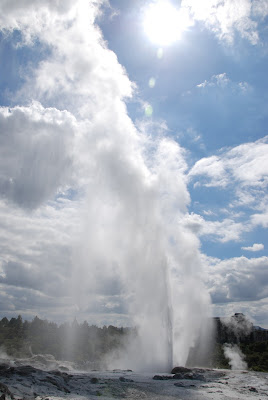 |
| The famous Pohutu Geyser in the Maori's "Te Puia" thermal area |
 |
| And again. It erupts every couple of hours |
 |
| Me in front of some of the steaming sulphurous landscape of Te Puia, Rotorua |
 |
| Bubbling mud pools in Te Puia, Rotorua |
 |
| Sulphur coating and staining the rock |
 |
| This is greenstone, a type of jade, which has mystical powers for the Maori. Under law they own all the native greenstone in New Zealand and are the only ones allowed to collect it. |
 |
| Maori dancing skirts in the weaving school at Te Puia. Since there were no mammals in New Zealand when the Maori arrived all their clothing had to be made from flax or bird feathers. |
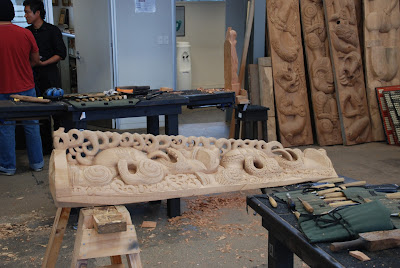 |
| A project under way in the Maori carving school in Te Puia, Rotorua |
 |
| Maori warriors arriving in a war canoe as part of the cultural show I attended in Rotorua |
 |
| A "haka" war dance |
 |
| The building behind the fire and totem is the Marai, or central meeting hall of a Maori tribal village |
 |
| Me with the sheep in the Agrodome outside Rotorua |
 |
| A sheep being shorn |
 |
| These are rams representing all the breeds of sheep which are to be found in New Zealand, the most prized being the Merino |
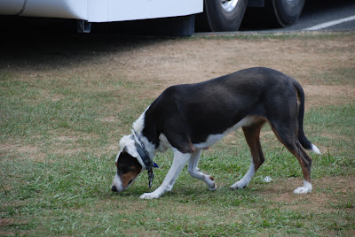 |
| As you can see, New Zealand sheep dogs are not like the ones you find in the UK or at Crufts. They are long legged and quite mongrel-like |
 |
| Spinning wool at the Agrodome. |


