This will be my last post for a while. I am now back in London and will probably not do any blog-worthy trips until later this year. But then again you never know..... I will be going to the Glastonbury Music Festival (my favourite) again this year at the end of June, so I will probably take some pictures and do a blog post, since it is such a unique and colourful experience.The Rolling Stones are headlining this year, for those of my generation. So if that interests you, check back in about mid-July.
This is the final post on my recent visit to New Zealand. I hope you have enjoyed this vicarious taste of this small island which has (deservedly) taken on such a high profile for tourists ( and film-fans) over the past 15 years.
Across the “Divide” and Queenstown
From the glaciers which I described in my last post, I drove through the isolated Haast Pass (the road was only paved in 1995) over the Southern Alps and across the “Divide”. The contrast is stark. Within a half an hour you move from dark green rainforest with melt-water rivers of the west, to bare brown hills and grazing lands of the centre and east.
The prevailing winds blow from the west and gather moisture as they cross the oceans which reach uninterrupted all the way to South America. The first land the winds strike for thousands of miles is the west coast of the South Island of New Zealand. And on the west coast are the ranks of mountains crumpled upwards by the incredible force of the Indo-Australian and the Pacific Continental tectonic plates colliding just off-shore. These mountains form a barrier to the winds which drop nearly all their moisture as rain on the narrow coastal plain and snow on the peaks of the Southern Alps, before passing over the mountain tops as dry winds, to the sheltered warmer interior of the South Island.
The interior across the Divide is not desert by any means—there are long, steep-sided lakes gouged out by the glaciers which once flowed off the Southern Alps: Lake Wanaka and Lake Hawea and further on the even larger Lake Wakatipu. Further north there are several more of these long thin north-south aligned lakes: Lake Pukaki and Lake Tekapo. The golden light on the blue waters of these lakes is lovely. But the temperature is higher and the landscape looks completely different.
These are all glacial lakes, formed by glaciers which used to run down the valleys on the east side of the Southern Alps. Because the interior of the South Island is hotter and drier, these glaciers melted away leaving behind these lakes. In contrast, the Fox and Franz Josef Glaciers (see previous post)which creep down the Southern Alps towards the west, remain as ice on the west side of the Divide, fed by the precipitation from the winds from the west, and they eventually melt as they reach sea level and flow into the Tasman Sea.
This central part of the South Island over the Divide, in the shelter of the western mountains, proved a more congenial place for European people to live, first as gold miners, then as cattle and sheep ranchers (which is still a very active part of the economy), and now as caterers to the thousands of tourists who flock here in summer and in winter.
The three main tourist towns are Wanaka, Arrowtown , and the biggest loudest and brashest of them all, Queenstown. Wanaka is a pleasant enough holiday resort in a fine situation on the lake of the same name. Arrowtown is a charming old gold-mining town on the banks of one of the rivers which feeds into Lake Wakatipu, and it is now a very sought-after up-market place to live. The humble little limestone miners cottages, shaded by plane trees (planted by the miners and now giants which dwarf the cottages), have become exclusive second homes for well-to-do New Zealanders and Australians.
Nearby Queenstown is the heart and soul of “yoof” tourism in New Zealand. Every conceivable ---and many plainly bizarre---outdoor activities and extreme sports are centred in Queenstown. It is over-flowing with gap year-ers, who throng the streets and the bars and eat at "Fergburger" (which serves the best burgers I have tasted in a long time).
Queenstown still offers its original claim to outdoor adventure fame: bungee-jumping. But that is pretty ho-hum these days. So there is paragliding, hang-gliding, parasailing,skydiving, zip lining, rappelling, ballooning,white water rafting, white water sledging, jet-boating, mountain biking, quad biking, trout fishing, sailing, canyon swinging, river surfing,kayaking—and that is only the summertime activities. The town has the four seasons covered with three (not very impressive) ski hills on the outskirts where extreme snow-boarding predominates.
Queenstown also has a surprising number of older tourists of all nationalities and plenty of top-of-the-range hotels and chichi restaurants to cater to them. There is also a thriving market for condominiums and holiday homes and apartments and villas for purchase or rent for holidaying well-to-do tourists. For those with the money and wanting a break from breaking their neck on some extreme sport, there are some fashion boutiques and two casinos. For those without the money or inclination for such indulgences there is the very fine Botanical Gardens on a promontory overlooking Lake Wakatipu.
And there is the fine 1912 coal-burning steamboat TSS Earnslaw which has been magnificently restored with its brass fittings and polished wood panelling and which still putzes across Lake Wakatipu belching smoke, to one of the nineteenth century cattle and sheep stations on the other side of the lake where wide-eyed city tourists can ride horses, have a barbeque and watch the activities of the still-operating cattle station or climb the steep hills which surround the station.
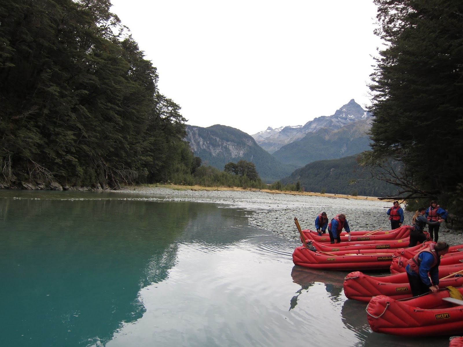
And yes I did do one outdoor activity. I went on a jet-boat trip up the Dart River from Glenorchy at the northern end of Lake Wakatipu and kayaked back down. It was fun although no-one had thought to tell me that if you sit on the outside of the jet-boat you will get soaked as the driver does one of his “thrilling” (not) 360 degree spins. Still, we were all kitted out in wetsuits and wind and waterproof jackets so it was not too too bad.
Jet-boats are quite interesting---because they are powered by hugely powerful jet engines, they just whiz over the surface of the water. Although they look like Formula One cars without the wheels, they can be used in water as shallow as 10 centimetres, so they are ideal for the wide-bedded and shallow, meandering, stony rivers with their frequently shifting channels.
The Dart River area is stuffed with film-sites not only from the Lord of the Rings but also from many TV ads which use the dramatic setting as a substitute for more expensive locations in the USA. Unfortunately I have only watched one Lord of the Rings film and I never watch TV, so a lot of it went over my head. The scenery was magnificent and I did enjoy the day despite being rather apprehensive when I first saw the wetsuits and the jet-boat!
In summary, Queenstown is definitely loud and lively—and expensive, but I don’t think I could take more than two or three days of it!
 |
| One of the beautiful lakes in the interior across the Divide. This one is Lake Wanaka |
 |
| and again |
 |
| This is Lake Hawea, which is less frequented and has steeper sides |
 |
| Lake Hawea again |
 |
| and again |
 |
| Lake Wakatipu looking west towards the eastern slopes of the Southern Alps |
 |
| Me at a lookout beside Lake Wakatipu |
 |
| Me kitted out in my jet-boating attire beside the Dart River |
 |
| Getting ready to push off in our inflatable kayaks which they call "funyaks" (really more like canoes) |
 |
| Beaching for a lunch break on the Dart River |
 |
| This stretch of mountains is apparently the scene which you will see in countless films ,including Lord of the Rings |
 |
| Entering the beautiful limestone Rockburn Chasm |
 |
| ditto. Notice the brilliant blue of the water, caused by dissolved minerals |
 |
| A high speed jet-boat taking part in a race. We just managed to beach our kayaks before they whizzed by us |
 |
| As you can see these competition jet-boasts look rather like Formula One cars without the wheels |
 |
| One of the nany channels of the wide, meandering Dart River with mountains behind |
 |
| A view at dusk westward Across Lake Wakatipu at the mouth of the Dart River, towards the western mountains |
 |
| These are some of the nineteenth century gold miners' cottages in Arrowtown, shaded by plane trees, now giants, which the miners planted to make their frontier town more "respectable". Arrowtown is now a very fashionable up-market village of second homes for wealthy Australians and New Zealanders. |
 |
| This miners' cottage in Arrowtown, like many, is built of limestone. Note the frontier-style false front designed to make the house look larger and more imposing, a style very common throughout the small towns and villages of New Zealand |
 |
| Typical Queenstown. Note the signage advertising extreme activities and "yoof" food like pizza and burgers |
 |
| The quite attractive waterfront of Queenstown, from which you can get pleasure boats up and down Lake Wakatipu |
 |
| The pretty and well-stocked Botanical Gardens on a promontory overlooking Lake Wakatipu and the town |
 |
| A not very good aerial view of Queenstown |
 |
| The wonderful old 1912 steamship TSS Earnslaw which has been beautifully restored and which takes tourists across the lake to one of the nineteenth century sheep stations. Note the smoke--it still burns coal. |
 |
| ditto |
 |
| Walter Peak sheep and cattle station across Lake Wakatipu, reachable only by water. |
Milford Sound
I went to the famous Milford Sound on a coach tour from Queenstown. That is really the only way to get there, but a visit to Milford Sound is absolutely de rigueur for any tourist to New Zealand’s South Island. It takes about seven hours to get there, although as the crow flies it is no distance at all, were it not for the impenetrable, tightly-packed granite mountains of Fjordland in between.
You need to drive 100 kilometres south of Queenstown, then 60 kilmetres west through grazing country past isolated farms and herds of deer, sheep and cattle, to the small community of Te Anau, in order to find an accessible route to take you 120 kilometres north again as the mountains close in around you, and eventually through the 1200 metre (one-way traffic only) Homer Tunnel through solid granite.
After seven hours driving, you end up only about 50 km as the crow flies to the west of Queenstown. As mentioned in my previous post, the geology of Fjordland is quite different from anywhere else in New Zealand. The rock is much harder and more ancient. Even though they were misnamed as “sounds” (ie drowned rivers) the heavily indented, steep sided inlets between the towering granite mountains, are in fact true fjords (formed by glacial action) like those in Norway or Greenland.
The whole of the south west corner of the South Island is fragmented and completely isolated by these fjords which indent the west coast's impenetrable mountains and the long thin glacial lakes Te Anau and Manapouri which run north-south down the centre on the island.
Since this is all such “new” land, nowhere on the planet (with the possible exception of Iceland) is it easier to see the dramatic effect of tectonic plate collisions scrunching up the granite into huge miles-high mountains of the hardest Pre-Cambrian granite, and the effect of glacial action gouging out valleys and fjords down both sides of these huge mountains ranges.
Needless to say Fjordland is uninhabited beyond a few tiny communities beside the road which runs through the valley of Lake Te Anau. It is a paradise for hikers for whom the Milford Track is one of the greatest hikes in the world.
Eventually you reach the small port at the end of Milford Sound where you embark on the cruise boats which take you for a couple of hours up the Milford Sound to its mouth at the Tasman Sea. It really is hard to get an idea of the scale of the sheer cliffs which line the fjord and plunge straight into the deep water (up to 440 metres deep) of the fjord. But these cliffs are over a kilometre high above the water and the huge ocean going cruise ships which often come into Milford Sound look like little motor boats. You can see the cracks in the cliffs where further tectonic action has split fissures in these giant monolithic walls. In fact the plates actually meet just outside the mouth of Milford Sound, and tectonic action continues today.
I decided to fly back to Queenstown (flying is getting to be an expensive habit!) rather than spend another 7 hours on the coach returning. The flight over these mountains and fjords and lakes reinforced the majesty and power of natural forces in this land.
 |
| On the drive into the Fjordland mountains, covered with rain forest on the lower slopes and in the narrow valleys |
 |
| One of the giant granite peaks, much more ancient and harder rock than the Southern Alps |
 |
| ditto |
 |
| Me beside one of the pure mountain streams |
 |
| higher up the granite valleys are waterfalls |
 |
| This is the amazing Homer Tunnel, started in the early 1930s' depression as a public works scheme but then abandoned and not completed until 1954. It is 1.2 km long through solid granite and is only one lane so you need to await the traffic light at the entrance until the oncoming traffic has cleared. It is the only land route into Milford Sound |
 |
| Through the Homer Tunnel you pass through the final mountain valley to the start of Milford Sound |
 |
| The docks at the inland end of Milford Sound |
 |
| Tourism is the only business of this part of the country and so the tour boats are plentiful and well appointed. This is the one I went on , the Milford Mariner |
 |
| view up the Miford Sound from the deck of the Milford Mariner |
 |
| ditto |
 |
| Note the scar on the cliff face. This is one of the many fault-lines that you see along the way, illustrating that the tectonic plates are still shifting |
 |
| This is a hanging valley, typical of fjords formed by glaciers. At one time there would have been a smaller glacier coming down that valley which would have been cut off by the main glacier which filled the Milford Sound up to that height, thus stopping the smaller glacier from continuing its grinding action |
 |
| Note the cliff soaring over a kilometre straight upwards to the sky |
 |
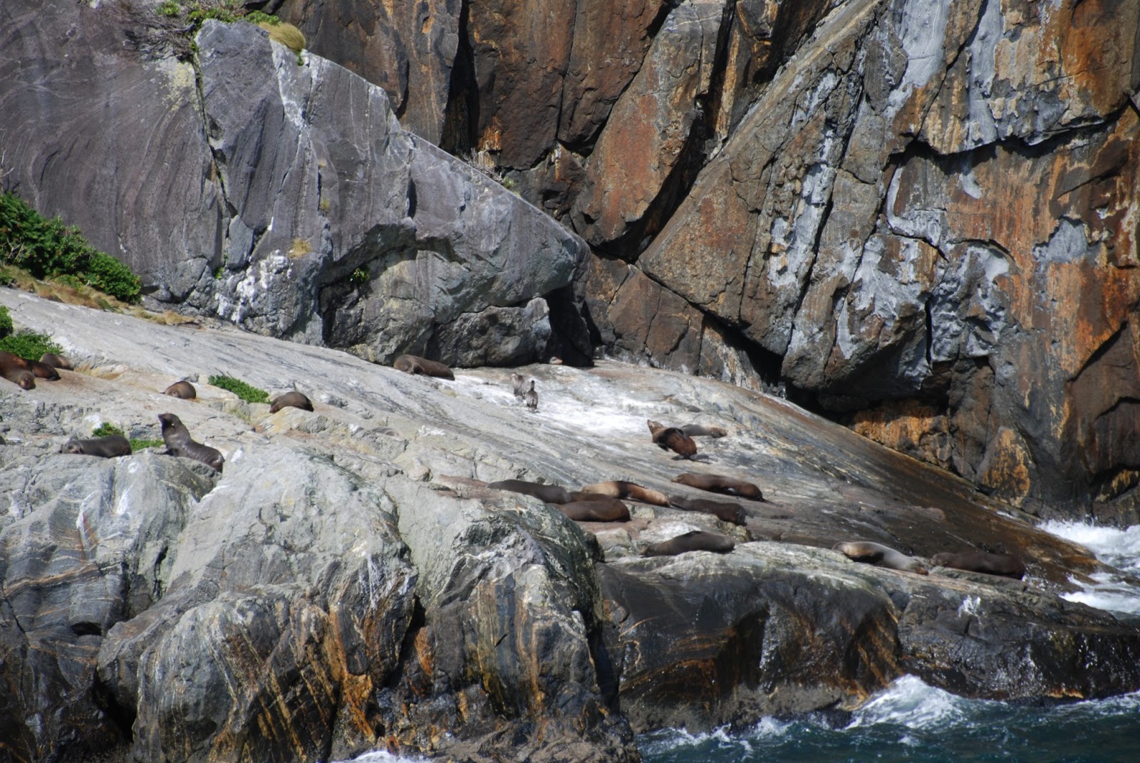
| The few areas along the walls of Milford Sound where there is flat rock , are a favourite place for fur seals to rest. |
 |
| This is one of the huge Princess Cruise Line ships, dwarfed by the cliffs of the Milford Sound |
 |
| And another view of the sound |
 |
| Apparently there are usually many waterfalls tumbling down the cliffs, but the season has been so dry that most of these have dried up or are reduced to a trickle. |
 |
| ditto |
 |
| Starting the flight back from Milford Sound to Queenstown |
 |
| a view up the valley where the world- famous hiking trail, the Milford Track, runs to reach the Milford Sound |
 |
| Another view from the air of a hanging valley. Note the waterfall at its end |
 |
| A view from the plane southwards over the other fjords of Fjordland |
 |
| the serried ranks of mountains of Fjordland, created by the collision just off shore of the tectonic plates |
 |
| Looking eastward, where the mountains are drier and so more barren. Note the lake formed in a valley of the mountain in the foreground |
 |
| snow capped granite peaks of the Fjordland mountains |
South and the East Coast
The east coast of the South Island was the first and the final stage of my trip, as I completed my circuit of the South Island and returned to Christchurch. I had already seen a part of the east coast when I drove from Christchurch to Picton to take the ferry to Wellington at the start of my trip, so I knew that this part of the South Island is by far the most populous and the effect of human habitation is unmistakable.
And this is not just because of European habitation. The Maori settlement of the South Island began in the north east and there are remains of their ‘pa’s (fortified hills) as well as evidence of the effect of their clearing the trees for cultivation and to make it easier to hunt (to extinction) the giant moa, or "big chicken" as they called it (you can tell what was on their mind when they gave it that name!).
All of the main towns of the South Island, settled primarily by Scots —Blenheim, Christchurch, Timaru, Oamaru, Dunedin, Invercargill—are along the east and south coast where the land is flatter, the ports more accessible, and the climate more settled and suited for habitation and cultivation. As a result the countryside is tamed and cultivated and the traffic heavier. The towns are mildly interesting –I found Oamaru, once a flourishing import-export centre with fine neoclassical commercial buildings of pure white limestone, particularly attractive. However all the towns have seen more prosperous times I think.
But the coastline is very fine in many places, such as the Catlins in the far south east and around Kaikoura in the north east, and just as dramatic as the west coast. There are plenty of places where you can (if you are lucky) see whales, blue penguins, yellow-eyed penguins, sea-birds of all kinds, and loads of fur seals lolling on the rocks. I also had a wonderful seafood lunch at "Fleur's Place" in the tiny fishing village of Moeraki Village on the east coast--Rick Stein, Gwyneth Palrow and Chris Martin are previous visitors. Highly recommended.
 |
| This is at Kaikoura on the north east coast. Look at the contours of the hill in the foreground. It was a Maori "pa" or fort., which would have been terraced and protected with stakes to repel attacks from other Maori tribes. |
 |
| The fine coastline at Kaikoura. As little as 40,000 years ago these cliffs would have been at sea level, but earth movements have elevated them to this height, and the lifting action continues as more land emerges from the sea. |
 |
| This is in the south of the South Island, in the area known as the Catlins. It is one of the oldest parts of New Zealand, having first emerged from the sea before the rest of the island. Very rugged and the home of plenty of seabirds and penguins, and whales passing close to the shore on their way to and from their feeding and calving grounds |
 |
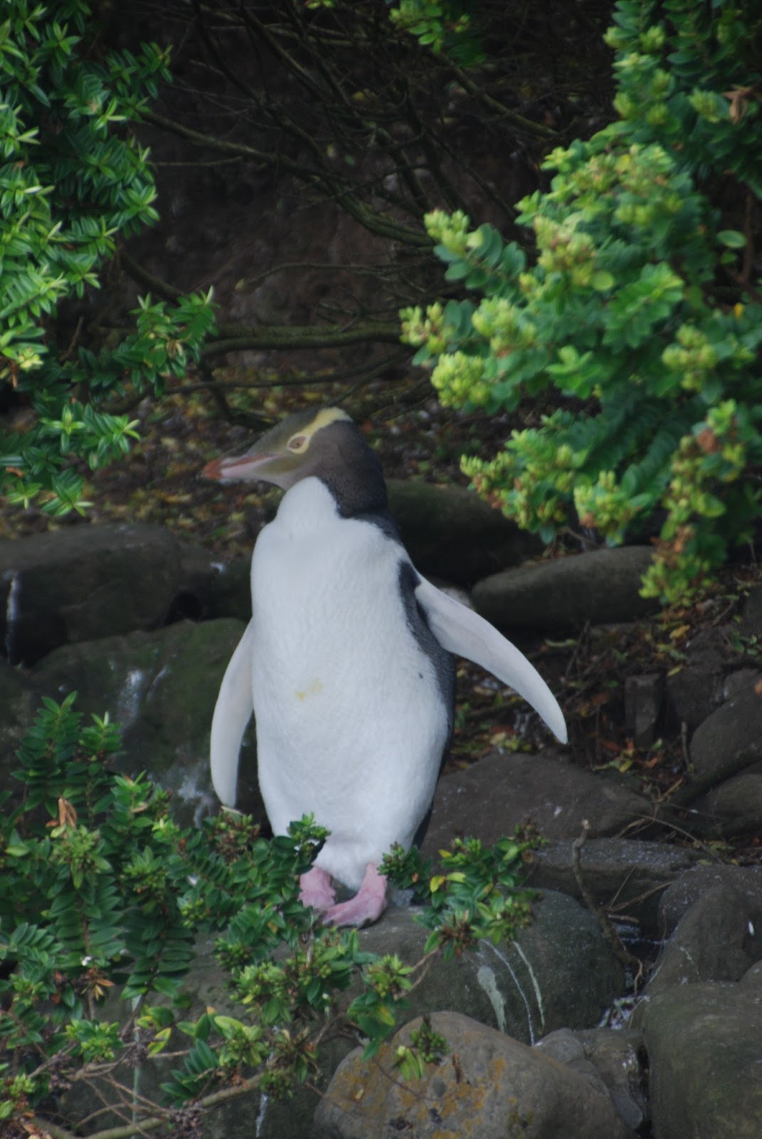
| One of the very rare yellow-eyed penguins, found only in New Zealand and its sub-Antarctic islands, and numbering only about 4000. They are the third largest of penguins, after the Emperor and the King |
 |
| And again. I was fortunate to get these photos of this rare and solitary penguin, because for a brief few weeks it is land-bound while it moults to grow a new set of feathers |
 |
| a red-billed oyster catcher |
 |
| This is a petrified tree trunk, in Curio Bay in the Catlins. The beach is littered with pieces like this, embedded in the rock and visible only at law tide. Apparently 180 million years ago this whole area was above sea level and covered with dense forest, although the rest of New Zealand was yet to emerge from the sea. As the sea started tor rise in one of its periodic shifts, this forest was flooded. At the same time a nearby volcano rained silica-rich lava down on the forest too. The trees soaked this up as they died and in a matter of weeks or months they were crystallised before they had time to decay in the rising salty marsh. |
 |
| This is the cliff along the edge of Curio Bay ( see last photo), showing the sedementary lawyers of sandstone, mudstone and limestone which show that the process of growth and flood occurred several times over the millenia. |
 |
| one of the perfect semi-circular sand beaches (this one in the Catlins) that are to be found all up and down the east coast of the South Island |
 |
| The wild and rough face of the Catlins on a grey and windy day |
 |
| a flock of sheep take to the road in the Catlins |
 |
| The lighthouse at the dramatic Nugget Point on the Catlins coast |
 |
| This was the best that my telephoto lens . These are fur seals parents teaching their pups to swim and dive, in one of the sheltered rock pools which form below the cliffs along the Catins' coast at low tide. |
 |
| The view from the Nugget Point lighthouse on the south east coast in the Catlins. Limestone stacks reminiscent of the formations along the west coast. |
 |
| The nineteenth century railway station in Dunedin, built of local limestone and bluestone. Dunedin was founded as a port on the east coast of the South Island by Scottish immigrants in the mid- nineteenth centuryand had the first university in New Zealand. |
 |
| The smaller and less well-known small city of Oamaru (rhymes with kangaroo) on the east coast north of Dunedin. It was famous for its pure white limestone, of which the many substantial commercial buildings in the town were built in the nineteenth century when it was a thriving wealthy export/import port. It was from Oamaru that the first shipment of frozen lamb was dispatched to Britain in 1882. It is now mostly famous for its thriving colonies of blue penguins (not allowed to take photos unfortunately!) and a small colony of yellow-eyed penguins. |
 |
| These are the strange Moeraki boulders which are found in one spot only on the east coast of the South Island. Some of then are as big as two metres in diameter. They are thought to have been formed as carbonate of lime crystal accretions around a central core of shell , which in turn attracted other minerals to form the network of veins . There were a lot more of them, of all sizes, but all that remain are the ones too big for souvenir hunters to carry off |
 |
| The excellent (and famous, although I didn't know it) Fleur's Place seafood restaurant in the fishing village of Moeraki |
 |
| Me in Fleur's Place, enjoying one the best seafood lunch I have ever had. |
And so I ended up back (at the excellent "George Hotel") in Christchurch after an exceptionally pleasant three weeks. I certainly plan a return visit to New Zealand.
While writing these blog entries, I have been reflecting on what most struck me about New Zealand. My perception of New Zealand had always been that it was a pretty, green, pastoral country dotted with sheep, a very safe and unthreatening country in an uncertain, violent world--like England, a "green and pleasant land". And in a way that is true --- on the human level.
What I had not realised was that behind that pretty face, lies a raw newly created land where nature has developed --and continues to develop--in a unique and extraordinary way, unlike any other land on the planet. This is the closest your are ever likely to get to experiencing the primeval forces that have shaped our planet for millions of years.