In this post and the next (final) one I
will continue describing and illustrating my recent tour through New Zealand in a camper-van. In particular in this post and the next one I will talk about the natural wonders of New
Zealand—the other-worldly volcanic area of the North Island and “Mount Doom”; the glorious west coast of the South Island
with its glaciers and the Southern Alps; Queenstown; Milford Sound; and a
little about the Catlins in the south; and the east coast of the South Island. There are some photos to bring it all to life.
Tongariro National Park and Lake Taupo
The centre of the North Island is an area of extraordinary
volcanic activity, both past and current. It is one of the largest such areas
in the world and dominates a large part of the small North Island. It consists
of a collection of extinct and active volcanoes in Tongariro National Park; the
enormous caldera lake, Lake Taupo; and stretches up to Rotorua (see previous
post) where Mount Tarawera last erupted in 1886 destroying the “Pink and White
Terraces” (silica formations) which had been New Zealand’s first international tourist attraction.
Dealing with Lake Taupo first, it lies at the northern end
of this volcanic area about 80 kilometres south of Rotorua (see previous post) . At first sight Lake Taupo looks like a large fresh water lake
with strangely uniform contours and "sand" beaches around its edge—it looks like a giant reservoir. In fact it is the
remains of a huge volcano which erupted in 186 AD, blowing itself completely
apart and leaving a giant hole. The “sand” around its edges is actually powdered pumice. Lake Rotorua to the north of Lake Taupo is also a caldera lake, but much older, formed by a similar massive explosion 250,000 years ago.
The eruption which created the Lake Taupo caldera was the most violent on earth in
the last 5000 years, many times larger than Krakatoa and Mount St Helens, and beating Vesuvius (which had erupted one hundred years earlier in Italy) into a cocked hat. Twenty-four cubic kilometres of rock, debris and ash
spewed forth and covered almost all of the North and the South Island.
The
Romans recorded that the sky turned blood red and the Chinese noted a
blackening of the sky. But of course unlike the eruption of Vesuvius which destroyed Pompei and Herculanuem, there was no human beings in New Zealand to witness it. Over the last 2000 years the crater has filled with rainwater
leaving a popular bathing and boating lake and a (ghastly) modern resort town.
And another characteristic feature of a caldera lake as opposed to the much more common lakes formed by glacial action, Lake Taupo has no rivers feeding it and only one outlet.
This one outlet is the hugely powerful Waikato River which is the longest in
New Zealand. In fact it is so powerful that the hydro-electric power stations
which have been built along it produce 15% of the New Zealand’s electricity.
Before the power plants, though, is the mighty Huka Falls. “Falls” is probably
a misleading name since the "fall" is only 11 metres and is only about 20 metres
wide, but it is like supercharged white water rapids through which 220,000
litres of water a second pass.
The main area of current volcanic activity lies south of
Lake Taupo and Rotorua, in Tongariro National Park. It consists of three huge
active volcanoes: Mount Tongariro, Mount Ngauruhoe and Mount Ruapehu. Mount Ruapehu is 2800 metres high
and last erupted in 2007, although the area has been on high alert for the past
few months. Believe it or not it is still the main ski area of New Zealand! The
New Zealanders must be mad!
Ngauruhoe (2300 metres) will be very familiar to Lord of the
Rings fans. It perfect volcano shape with black and red lava running down
its sides and steam puffing from its cone,made it shoe-in to star as “Mount Doom”. It is only 5000 years old
and last erupted in 1975. In fact volcanologists now consider Mount Ngauruhoe
to be a vent for its very active neighbour Mount Tongariro (2000 metres). Mount Tongariro is the oldest of them having formed about 275,000 years ago , but also
currently the most active. It has 12 craters belching steam and yellowish green
sulphurous mud. The latest eruption was in December 2012!
Tongariro also has
several lakes accumulated in its various dormant craters—Blue Lake is the largest at 16.5 metres deep and 400 metres wide,
very acidic and cold despite the heat of the volcanic activity beneath it. The
Emerald Lakes are also cold and acidic but (as the name implies) a different
colour. The Red Crater is impressive—the crater walls are stained red from the oxidised iron and rock. The north crater of Mount Tongariro is more than a kilometre wide and table top
flat because it is solidified lava.
As you will have gathered, I did not see all this by hiking
up the mountains! I splurged and took a flight over the area in a small plane.
It was the best idea I have had in a long time and worth every penny. You
simply cannot get any concept of the magnitude and jaw-dropping
other-worldliness and power of the area from the ground. See some of my photos
….
 |
| Lake Taupo and the "sand" beach which attracts local families for "bucket and spade" holidays |
 |
| The violently powerful flow of the Waikato River, the only outlet for the huge Lake Taupo |
 |
| The Haka Falls over which flows 220,000 litres of water a second |
 |
| The ski lift at Mount Ruapehu, the main ski hill of the North Island. Note the lava which covers the whole mountain, which last erupted in 2007 and may do so again at any time! |
 |
| Me at the cafe at the top of the Mount Ruapehu ski lift |
 |
| The light plane in which I flew over the volcanoes |
 |
| The three main volcanoes of Tongariro National Park. Mount Tongariro in the foreground, currently the most active, Mount Ngauruhoe ("Mount Doom" from Lord of the Rings) in the middle and the highest, Mount Ruapehu with the snow on the peaks, in the background. |
 |
| "Mount Doom" |
 |
| The crater of Mount Ngauruhoe from above |
 |
| Some of the still active craters of Mount Tongariro |
 |
| Craters of the various volcanoes of Tongariro National Park |
 |
| One of the highly acidic lakes which have formed in some of the craters. They are cold, despite the heat of the volcanoes beneath them |
 |
| The caldera Lake Taupo in the background and the smaller crater lake Rotoraia in the foreground (not to be confused with Lake Rotorua which is also a caldera lake about 80 kilometres beyond Lake Taupo |
 |
| Crater lakes of Mount Tongariro and Mount Ruapehu behind. The crater lakes are all different colours, depending on their chemical content, ranging from indigo blue to emerald to turquoise |
 |
| The milky blue crater lake at the top of Mount Ruapehu. The colour of this lake is used as an indicator of the volcanic activity beneath. Milky blue indicates that there is a serious danger of a further eruption. |
 |
| A view over Mount Ruapahu looking north |
 |
| A volcanic field. These humps are extinct volcanoes. In a volcanic field there are many small volcanoes that only erupt once and then become extinct. |
The Marlborough Sounds, the West Coast of the South Island
After my tour of the North Island, I arrived back on the
South Island from Wellington by car ferry across the Cook Strait between to
North and South Islands, to Picton which is in the Marlborough Sounds. The
Sounds are made up of a maze of islands and wildly indented peninsulas covered by
steep hills dropping precipitously to the water’s edge. Many of these are still
forested but a lot have been clear-cut of trees and are stark and bare which is really sad and makes then rather an eye-sore. Looking at them you would assume that these islands and peninsulas are the tops of underwater ridges heaved up from under the sea. But in
geographical terms these sounds are drowned valleys.
In other words the hills and the valleys between them were
once above water but the shifting of the tectonic plates tipped them towards
the north east, letting in the sea and drowning the valleys leaving only the
hill tops exposed. (This contrasts with the “Milford Sound” and “Doubtful
Sound” in the south west coast (see next post) which are not "sounds" at all but are "fjords" formed by glaciers from the mountains carving valleys as they ground their way
downhill to the sea.)
Although you get a very good idea of them from the ferry, I didn’t have the necessary time to see the Marlborough
Sounds properly nor the adjacent Abel Tasman National Park on this trip. Instead I headed west through the flat grazing lands along the wide Wairu River valley
with mountains in the distance on both sides. It reminded me a lot of stretches
of the US west.
The Wairu is a typical “braided river” of which there are many
in the South Island. There is a lot of water in these rivers but the flow criss-crosses through many large and small channels
in a stony river bed hundreds of metres wide.
As you near the west coast of the South Island, the valley narrows and enters the
western mountains which run the length of the west coast, rising to their
highest as the Southern Alps and then shattering into the fjords of Fjordland
in the south west.
These western mountains are very young in geological terms—three
million years. They have resulted from the collision of the tectonic plates
which meet just at the coastal edge of the South Island. The Pacific Continental Plate has been thrust upwards
as the Indo-Australian Plate pushes underneath it. Thus you can see the strata
of rock folded and thrust upwards and because they are so new there has been
little time for erosion to smooth them out and wear them down.
The rock of
which they are composed varies, though. In the north right down to the Southern
Alps, the predominant rock is soft—sedimentary strata of limestone, sandstone
and even mudstone (which as the name implies is mud which has been compacted
into a soft-ish rock). But further south, in Fjordland, the rock is much more
ancient and hard—Pre-Cambrian igneous rocks like gneiss.
So it is quite possible that if you come back in another few
million years the middle and northern stretches of the west coast with their
relatively soft sedimentary rock will be nice gently eroded rolling hills while
in the southern stretches and the fjords of Fjordland there will still be high
rugged mountains because the rock is so hard it takes much longer to erode. But
then of course anything can happen in New Zealand---the tectonic plates keep
grinding, the earthquakes keep rumbling and the volcanoes keep erupting.
The drive down the west coast of the South Island is billed
as the rival for variety and natural beauty of Highway 101 down the west coast
of USA. It has no major cities (or indeed any cities at all!) and it is not
nearly as long as US Highway 101(which is 2500 km compared to the drive-able part
of the New Zealand West Coast --Highway 6 --which is 538 km of which I drove 420 km). But in
that distance it packs in an enormous amount of Wow!
The population is very small, and declining. The settlements
that there are, grew from the mining rushes of the late 1800s and early 1900s. Gold was the big
draw. There is a very small amount still going on but gold mining was not
really cost effective and in today’s environmentally conscious times the huge
destruction of trees, pollution of water and erosion of the land would simply
not be tolerated.
So the little frontier mining towns with their main street of
false-fronted shops and tiny wooden bungalows gradually moulder as their
populations drift away. There is still coal mining going on in some of the
valleys which run parallel to the coast behind the first range of western
mountains, but for the most part the west coast relies on tourism.
And the drive down the coast is scenically outstanding:
deserted sandy coves littered with driftwood, wild and weird limestone stacks,
and the remnants of the old rainforests which used to cover the western slopes
of the mountains and this narrow coastal strip. The strong,
precipitation-loaded prevailing winds come from the west –nothing between this
coast and the coast of South America. They hit the mountains and drop their
load of rain, nourishing lush vegetation and creating thousands of rivers and
rivulets flowing into the sea, before passing over the mountains as dry winds
to the hotter and grassy tree-less plains and low hills of the eastern part of
the South Island. This is “The Divide”.
 |
| The Marlborough Sounds which lie at the north end of the South Island, separated from the North Island by the fairly narrow Cook Strait. These are "drowned valleys", meaning they used to be ranges of hills and valleys above sea level but shifts in the land tilted them so that the sea flowed into the valleys leaving only the hilltops above water as islands or peninsulas. |
 |
| There is much ferry and freighter activity in the Marlborough Sound since unless you fly, it is the only link transport between the North and South Islands. |
 |
| The beauty of the Marlborough Sounds are not infrequently broken by these gashes of clear-cut "harvesting" of trees. |
 |
| Ferries plying the waterways of the Marlborough Sounds |
 |
| Marlborough Sounds |
 |
| The ferry terminal town of Picton. martime transport, whether goods or vehicles or people, is big business here. |
 |
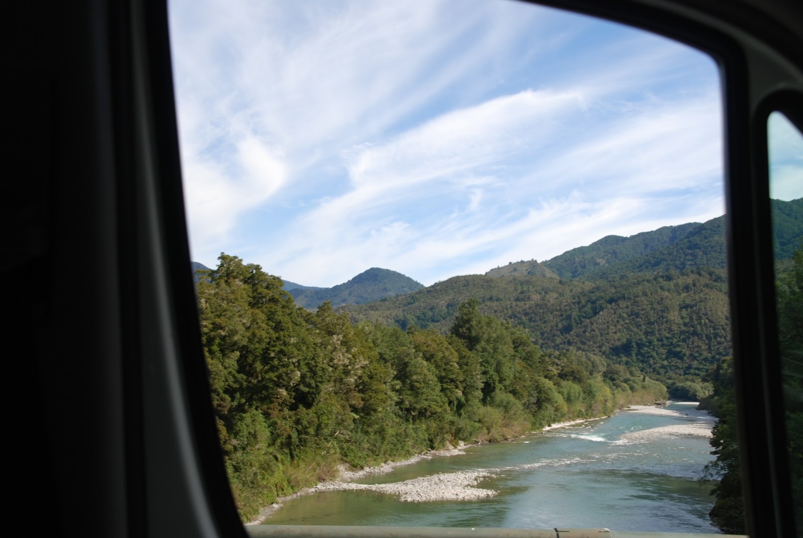
| One of the wide "braided" rivers which are found in many parts of the South Island. This one is the Wairau which runs through a wide valley from west to east in the northern part of the South Island and is one of the routes to the famous West Coast of the South Island. |
 |
| As you get further west the river narrows as the mountain ranges on either side close in. This was snapped quickly from one of the one-lane bridges of which there are hundreds in the South Island. |
 |
| This is the Buller River which flows into the Wairau. Note the limestone bed and banks. Limestone predominates in the mountains of the west coast, until you reach the southern Fjordland ( covered in my next post) which is made of much harder granite |
 |
| A swing-bridge crossing the Buller River |
 |
| The Buller again. The right bank is nearly 12 feet higher than it was a century ago since it was heaved up in one of the massive earthquakes which have formed and transformed and continue to transform New Zealand. |
 |
| Cape Foulwind on the West Coast, looking very docile in the early morning. My camper-van in the parking lot below. |
 |
| Limestone "stacks" like these litter the West Coast |
 |
| One of the many deserted sand beaches down the West Coast. note the coastal mountain ranges, formed by tectonic plates clashing (see blog for explanation) |
 |
| Another cove along the West Coast. Note the abundant wind-swept vegetation |
 |
| another offshore limestone island |
 |
| And again--note the strata of limestone on the left |
 |
| ditto |
 |
| ditto |
 |
| Because of the abundant rainfall on the west coast (see blog) any sheltered spot is filled with rainforest trees and ferns. |
 |
| This is a "cabbage tree". It is not a palm tree, but a heath plant. Very common to see these in gardens as well. |
 |
| Note the "pancake" strata |
 |
| Cormorants dry their wings on the limestone stacks |
 |
| Note the luxuriant vegetation on the sea side cliffs |
 |
| As you get further south the coastal strip widens and there are some side sandy beaches covered with driftwood |
 |
| A first glimpse of the Souther Alps across a small lake |
The Southern Alps and the Glaciers
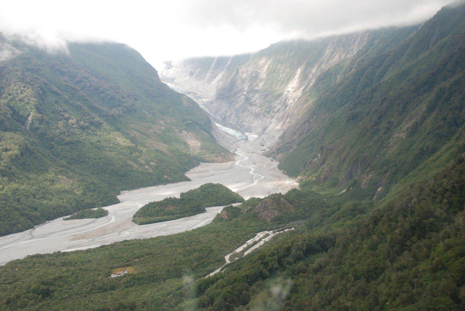
As you move further south down the west coast, the lower coastal
mountain ranges give way to the snowy peaks of the Southern Alps. So you can be
driving along the wooded coast road and clearly see the Franz Josef Glacier (11
kilometres long), and the Fox Glacier(13 kilometres long and only 25 kilometres
further on from the Franz Josef).
These are remarkably close to the coast and this gives rise to the
unique phenomena of glaciers descending through steep-sided valleys from the 3000
metre heights of the Southern Alps to dense rain forest with grey-blue
melt-water rivers snaking through, and then on to the coast, in a distance of a
mere 25 kilometres.
I wasn’t entirely lazy and I did walk up to the base of the
Fox Glacier but you really do need to fly over this remarkable area to get a
real appreciation. So once again I splurged on a helicopter flight from the
coastal plain, over the rainforest and up the Fox Glacier to view the peaks of
Mount Cook (3754 metres), Mount Tasman (3498 metres), Mount Sefton (3157
metres) and others, and in the distance the east coast of New Zealand.
You see
the crumpled mountain peaks—like aluminium foil scrunched up and loosely
unfolded—as far as the eye can see north and south. You can almost visualise
the force of those tectonic plates colliding and ploughing up the rock.
We landed amongst the mountain-tops where the Franz Josef
glacier forms. It is almost impossible to grasp the scale of these mountains.
The helicopter pilot pointed out a couple of tiny specks of dirt on the snow
below us and told us they were other helicopters, and sure enough they were as
we saw when we came into land besides them amidst the crevasses.
The next post will carry on this story...
 |
| From the helicopter:----The bottom of the Franz Josef glacier where its moraine slows through rainforest. |
 |
| A little further up with the glacier itself visible through beneath the low cloud cover that day |
 |
| Flying over the base of the Franz Josef, note the crevasses where the ice is buckling as it presses through the narrowing valley and picking up dirt and rocks from the sides and base of the valley through which it flows |
 |
| Further up the Franz Josef above the clouds |
 |
| looking back to the cloud-shrouded valley below |
 |
| Above the clouds flying over the Southern Alps |
 |
| Mount Cook and the other highest peaks of the Southern Alps where the Franz Josef and Fox Glaciers begin |
 |
| Mount Cook |
 |
| Looking east through the peaks towards Lake Pukaki and beyond over to the East Coast of the South Island |
 |
| Looking north along the Southern Alps. The Tasman Glacier on the right |
 |
| Looking south across the Southern Alps and the cloud-shrouded valleys toward the west coast and the Tasman Sea |
 |
| Coming into land on the top of the Franz Josef Glacier. Note the little specks in the centre---they are other helicopters |
 |
| Me on the Franz Josef Glacier at its starting point |
 |
| Note the angle of the strata of rock, which shows the power of the tectonic plate shifts. |
 |
| on the Franz Josef way above the clouds in brilliant sunshine |
 |
| I later walked up to the base of the Fox Glacier through its moraine river bed |
 |
| The base of the Fox Glacier |
 |
| Note how the snow turns to bare rock and then to rainforest-clad slopes in a matter of a couple of kilometres |
 |
| ditto |
 |
| one of the lower valleys covered in dense rain forest |
 |
| Rainforest close to the base of the glaciers |


No comments:
Post a Comment